 "Justin Hughes" (justinhughes54)
03/09/2016 at 16:20 • Filed to: epic drives, cabot trail, cape breton island
 4
4
 18
18|
"Justin Hughes" (justinhughes54)
03/09/2016 at 16:20 • Filed to: epic drives, cabot trail, cape breton island | 4
| 18 |
Recently the web site !!!error: Indecipherable SUB-paragraph formatting!!! has been making headlines, inviting Americans seeking to flee a potential Trump Presidency to move to Cape Breton Island, Nova Scotia. It’s actually much more difficult than that for an American to !!!error: Indecipherable SUB-paragraph formatting!!! , but that doesn’t mean we can’t visit. And politics aside, the roads and scenery there are worth visiting no matter who you vote for. In fact, I’d say it’s the most beautiful place I’ve ever been, and the Cabot Trail is the best way to see it.
Read on Right Foot Down or continue below
The Cabot Trail is a 185 mile (or 298km, as they measure it there) loop around the northern part of Cape Breton Island, Nova Scotia. I’ve heard it called the Pacific Coast Highway of the east coast, and one of the most fun roads in the entire northeast. It’s a pretty lofty claim, but I wanted to see for myself someday. In July, 2013, a somewhat expected loss of a job suddenly gave me a lot of time, and my planning for that loss gave me a fair bit of savings. I decided to take a trip out there to see it for myself before diving into the search for a new job, since I was unlikely to take a summer vacation after I started one.
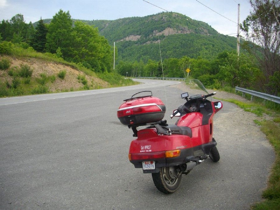
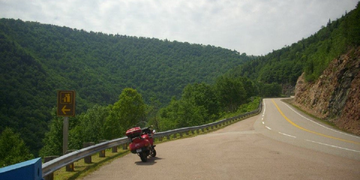
Rather than taking the 2003 Ford Crown Victoria Police Interceptor that I drove at the time I decided to take my 1998 Honda Pacific Coast 800. Yes, it’s a motorcycle, not a car. I didn’t have my BRZ at the time, so the bike seemed the most fun way to go, plus it’s much better on gas mileage. You can read all about the motorcycle related details of the trip over on my bike travel blog, !!!error: Indecipherable SUB-paragraph formatting!!! , and the Cabot Trail can be thoroughly enjoyed by car as well.
Getting There
At the time I took my trip, there was no ferry between Portland, ME and Yarmouth, NS. This has been a troubled on-again, off-again relationship for many years, with !!!error: Indecipherable SUB-paragraph formatting!!! followed immediately by !!!error: Indecipherable SUB-paragraph formatting!!! for unpaid debts. Details on the new ferry service aren’t available at the time of this writing, so use the Googles to look it up.
For the moment, you’ll have to do what I did and make the entire journey by land, all the way across Maine and New Brunswick. There are two main routes you can go. You can either take I-95 all the way to Houlton, ME, then take Trans-Canada Highway 2 across NB. The speed limit on I-95 has increased to 70mph through most of southern and central Maine, and 75mph north of Old Town (the canoe place just past Bangor). If you want to make good time on deserted highways, this is the place to do it, and do it legally. It’s the highest speed limit in the US east of the Mississippi River. Or you can do what I did, take Route 9 out of Bangor through the middle of nowhere to Calais (pronounced “KAL-us,” just to annoy the French speakers), and take secondary roads across NB from there. These roads are not in very good shape, so I eventually changed course toward T-Can 2 and took the superslab.
!!! UNKNOWN CONTENT TYPE !!!
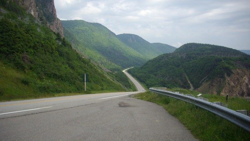
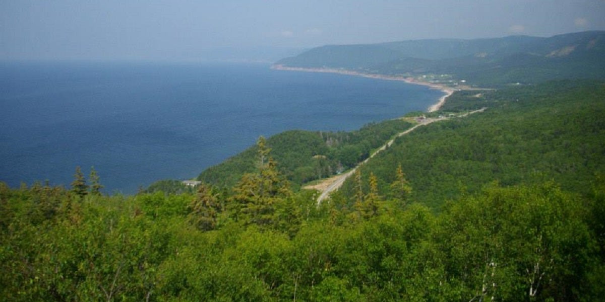
However you get there, T-Can 2 becomes T-Can 104 after crossing into Nova Scotia. The difference is night and day. Pavement quality improves, and so does the scenery. The views that revealed themselves over the crest of every hill took my breath away.
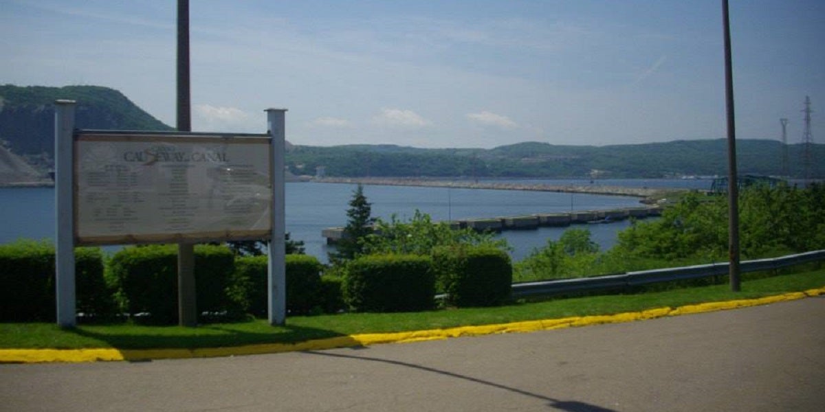
T-Can 104 takes you all the way across the Canso Causeway and onto Cape Breton Island. Back in the 1950s you didn’t need a billion conservation studies and building permits to blast half a mountain away, dump it into a strait, and make a road. They also didn’t understand the disastrous effect it would have on fish migration. The answer to the terrible joke “Why did the fish cross the road?” is “They can’t,” but people were surprised when the area’s once strong fishing industry collapsed after the causeway was built.
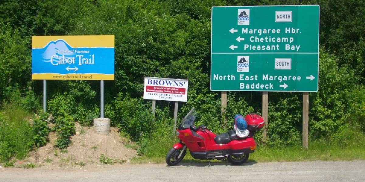
Just after the Canso Causeway, change to T-Can 105 at the traffic circle, which joins the Cabot Trail near Nyanza. You may notice that the bilingual town name signs here are not Canada’s typical English and French, but English and Gaelic!
The Road
There’s some debate as to whether it’s better to drive the Cabot Trail clockwise or counter-clockwise. Most people seem to prefer clockwise, so I decided to take it counter-clockwise to cut down on traffic. It also put me closer to the shore and many of the pull-offs. The general concensus seems to be that it’s best to drive it in both directions and decide which you like better.
I don’t function well without coffee in the morning, so I stopped at a Tim Horton’s soon after I set off from my campsite in Baddeck, which is pretty much at the center of Cape Breton Island. A Harley parked next to me, and the rider turned out to be a local school teacher who enjoyed riding the Cabot Trail during summer break. He advised me to stick to the posted speed limits. Most of us are used to doing 60mph around highway on-ramps posted at 25, but when the Cabot Trail posts a corner at 40km/h (25mph), they mean it. It really is that tight. And it has nothing to do with police. I saw a grand total of two cruisers during my entire week on the road in Canada, and neither was running a speed trap. The main concern is wildlife. Taking a corner too fast and finding a moose standing at the apex will ruin your day, as well as your bodywork.
In stark contrast to most of New Brunswick, the entire Cabot Trail has excellent pavement. This amazed me, since Cape Breton Island sits at the same latitude as northern Maine, which does not have good pavement. My native Massachusetts has terrible roads, and so did New Brunswick, yet somehow the Cabot Trail remains delightfully intact despite being further north and open all winter.
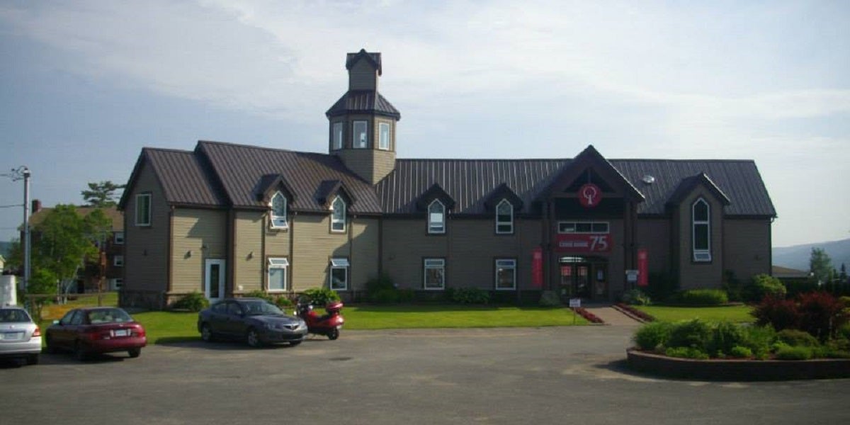
Soon after heading north from Baddeck, I made a stop at !!!error: Indecipherable SUB-paragraph formatting!!! in Saint Anns. I’m a history buff. My persona in the !!!error: Indecipherable SUB-paragraph formatting!!! is Scottish, and since Nova Scotia (literally “New Scotland”) was the destination for many Scots during the !!!error: Indecipherable SUB-paragraph formatting!!! , there is a vast amount of Scottish culture cherished and preserved here. I was able to research and learn quite a bit about my own persona’s clan - Clan MacRae. (See? We’re getting back to cars eventually.)
The Cabot Trail’s complexity hits the sweet spot between enjoyable and technical. The steep climb up Smokey Mountain was one of the most technical climbs I’ve ever made, but the vast majority of the Cabot Trail is curvy and hilly without taking your attention away from the awesome scenery around you. But there are also plenty of places to pull off, take a break, and take in the scenery.
Read on Right Foot Down or continue below
The Cabot Trail passes through the !!!error: Indecipherable SUB-paragraph formatting!!! . You are not required to pay park admission if you’re passing straight through, but if you so much as set a foot down in the park you’re expected to pay admission as you enter. There are convenient little booths just off the side of the road so you can pull off and pay easily. I highly recommend that you do it. There are many beautiful places to check out in the park, and it’s worth not having to worry about getting ticketed for not having a pass (the rangers do check). It was $7.80 when I went. And !!!error: Indecipherable SUB-paragraph formatting!!! , celebrating Canada’s 150th anniversary.
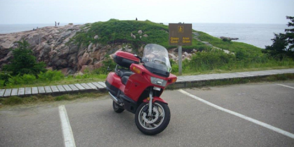
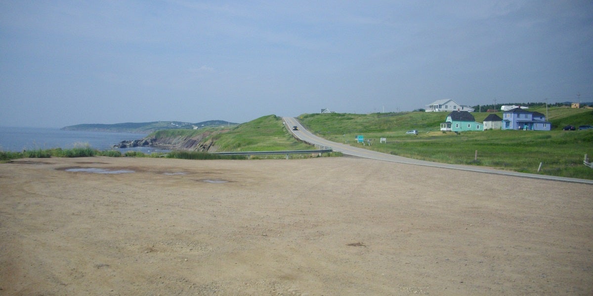
!!!error: Indecipherable SUB-paragraph formatting!!! , on the eastern side of the island, is a great place to stop and explore. It’s a rocky outcropping into the Atlantic Ocean, covered with scrubby looking trees and bayberry bushes. The reddish granite caught my eye as being quite similar to what I’ve seen at Acadia National Park in Maine, hundreds of miles away.
There are some enjoyable scenic detours off the Cabot Trail as well. I missed one down to Neil’s Harbour (when in Canada, spell as the Canadians do) which would have taken me on an enjoyable twisty cruise along the shore, as well as fed me a good cup of chowder at Murdoch’s Rock. I did take Bay St. Lawrence Road all the way to the end, and watched some lobster boats come and go from the bay. I was too chicken to try Meat Cove Road because it was gravel, but in a car I’d definitely give it a try for even more spectacular views.
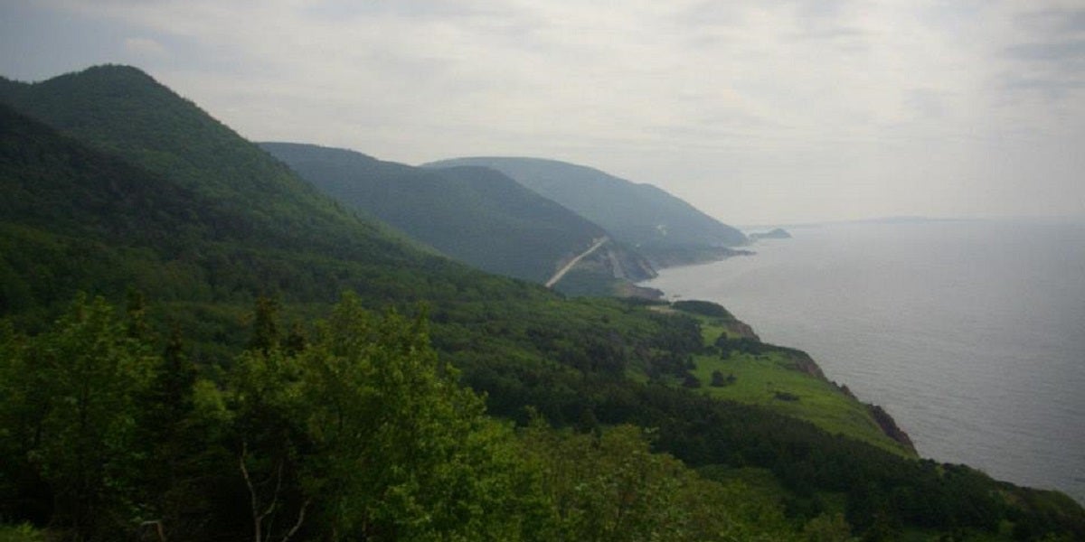
After rejoining the Cabot Trail, it soon dives back into the park, leading to even more swerves and curves among the lush green forests. You end up along the coast again in the aptly named Pleasant Bay, then gain altitude rapidly through a series of switchbacks up the side of Mackenzie Mountain. Unlike the somewhat chaotic climb of Smokey Mountain, which tend to follow the terrain, the climb (or descent, depending on your direction) up Mackenzie is organized and methodical.
Though the road doesn’t take you to its 1,366ft peak, it takes you plenty high enough to look back for miles from whence you came. While admiring the view myself, a BMW motorcycle with a distinctive exhaust note went by. Though reasonably quiet, I could still hear it nearby for the next five minutes or so, and saw it emerge from the trees not very far from me as far as horizontal distance was concerned.
As you cruise down the east coast of Cape Breton Island watch for whales mucking about in the water nearby. I didn’t see any myself, but according to the park ranger I talked to this is a very popular area for them. Indeed, as I left the park and rolled into Chéticamp, I noticed numerous whale watch rides available. Clearly they didn’t have far to go to give their customers a good show.
Speaking of Chéticamp, this area of Cape Breton Island has a strong Acadian population. The island bounced like a ping pong ball between France and Great Britain through treaties and wars until finally being reunited with British Nova Scotia in 1820. (I told you I’m a history buff.) French replaces Gaelic on road signs in this area, and the !!!error: Indecipherable SUB-paragraph formatting!!! is as visible as the Canadian flag, if not more so. This fishing village is quite proud of their culture. The Cabot Trail becomes less twisty and curvy, so just slow down and take in the culture for a while before turning back inland at Margaree Forks and returning to the trees. Alternately, you can take the Ceilidh Trail south through Inverness (why yes, Scottish culture takes over again) and all the way back down to Port Hastings and the Canso Causeway.
Even before I left Cape Breton Island, I vowed that I would return someday to explore it some more. There are many places, like the !!!error: Indecipherable SUB-paragraph formatting!!! , right along the Cabot Trail that I’d like to see, and others, like the !!!error: Indecipherable SUB-paragraph formatting!!! , not far off the trail. Next time I’d like to take a fun sporty car, like !!!error: Indecipherable SUB-paragraph formatting!!! or something else, try the Cabot Trail clockwise, and explore some areas I haven’t been to yet. Regardless of who becomes our next President, I doubt I’ll be fleeing to Canada anytime soon. But I definitely plan on returning to Cape Breton Island.
Follow @justinhughes54 on Twitter
 Phyrxes once again has a wagon!
> Justin Hughes
Phyrxes once again has a wagon!
> Justin Hughes
03/08/2016 at 21:48 |
|
Nicely done, the last time the Mrs. and I made it that way was PEI for our honeymoon. Bonus points for working the SCA into the narrative.
|
Justin Hughes
> Phyrxes once again has a wagon!
03/08/2016 at 21:51 |
|
Thanks! I’ve never been to PEI but I need to check it out sometime myself. Or should I say Tir Mara?
 RallyDarkstrike - Fan of 2-cyl FIATs, Eastern Bloc & Kei cars
> Justin Hughes
RallyDarkstrike - Fan of 2-cyl FIATs, Eastern Bloc & Kei cars
> Justin Hughes
03/08/2016 at 22:07 |
|
Yay! Great write-up and gorgeous pics! Glad you enjoyed my neck of the woods! I’m not a Cape Bretoner, but I live on Nova Scotia’s South Shore near Mahone Bay! :)
The Cape Breton Highlands are beautiful...I’ve only been once when I was younger, but I definitely want to head up that way again sometime. The Fortress at Louisburg is very well done and there are often still archaeological digs going on there from time to time - very cool for history buffs!
|
Justin Hughes
> RallyDarkstrike - Fan of 2-cyl FIATs, Eastern Bloc & Kei cars
03/08/2016 at 22:10 |
|
Thanks! Looking forward to getting back there sometime, and exploring the rest of NS. Maybe the ferry to Yarmouth will start running again someday and I can cross the whole province.
|
Phyrxes once again has a wagon!
> Justin Hughes
03/08/2016 at 22:13 |
|
We are Aethelmarc citizens but currently reside in Atlantia, if you haven’t ever been to Pennsic you need to!
|
RallyDarkstrike - Fan of 2-cyl FIATs, Eastern Bloc & Kei cars
> Justin Hughes
03/08/2016 at 22:15 |
|
Here’s hoping! Hit me up if ever you do, haha! :)
|
Justin Hughes
> Phyrxes once again has a wagon!
03/09/2016 at 06:48 |
|
Can’t make it this year but I’ve been to the past few.
I’m from the East, and my lady considers Ealdormere home.
|
Phyrxes once again has a wagon!
> Justin Hughes
03/09/2016 at 07:39 |
|
Fair enough, I haven’t made it recently but a toddler will do that.
 TheNeonDriver - Now with More BMW!
> RallyDarkstrike - Fan of 2-cyl FIATs, Eastern Bloc & Kei cars
TheNeonDriver - Now with More BMW!
> RallyDarkstrike - Fan of 2-cyl FIATs, Eastern Bloc & Kei cars
03/09/2016 at 09:07 |
|
Where near Mahone Bay? I grew up in that area, right near Squid Cove...
 Luc - The Acadian Oppo
> Justin Hughes
Luc - The Acadian Oppo
> Justin Hughes
03/09/2016 at 16:31 |
|
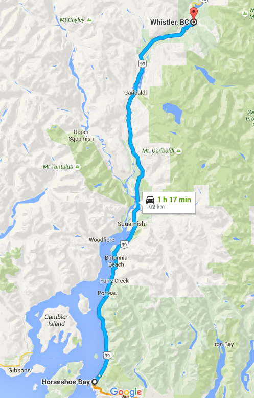
I’ve never done the Cabot trail even tho I grew up 6 hours from there. But the best road I have ever driven to date is BY FAR highway 99 in between West Vancouver and Whistler.
|
Justin Hughes
> Luc - The Acadian Oppo
03/09/2016 at 16:34 |
|
It’s on the other side of the country from me, but if I ever end up out that way I’ll be sure to check it out!
 Eberle-Hills-Cop
> Luc - The Acadian Oppo
Eberle-Hills-Cop
> Luc - The Acadian Oppo
03/09/2016 at 16:39 |
|
As far as paved roads go, this 100%
 Andrew
> Justin Hughes
Andrew
> Justin Hughes
03/09/2016 at 16:46 |
|
I drove this and it was fantastic
 The Crazy Kanuck; RIP Oppositelock
> Justin Hughes
The Crazy Kanuck; RIP Oppositelock
> Justin Hughes
03/09/2016 at 16:53 |
|
Not pictured: an RV going down it super slow.
|
Justin Hughes
> The Crazy Kanuck; RIP Oppositelock
03/09/2016 at 16:57 |
|
Ha! I lucked out on that, either by going counter-clockwise or by going during the week, not a weekend.
 Jarrett - [BRZ Boi]
> Justin Hughes
Jarrett - [BRZ Boi]
> Justin Hughes
03/09/2016 at 18:06 |
|
I’m road tripping the Miata from Toronto to New Brunswick in the summer. Maybe I’ll have to take a detour...
 Eric @ opposite-lock.com
> Luc - The Acadian Oppo
Eric @ opposite-lock.com
> Luc - The Acadian Oppo
03/09/2016 at 18:09 |
|
There are some awesome roads in this area. The Sunshine Coast Highway west of Halfmoon Bay is really fun (and the speed is posted so high that in most cars you’ll have a hard time exceeding it).
|
Justin Hughes
> Jarrett - [BRZ Boi]
03/09/2016 at 20:03 |
|
It’s a big detour, but I think it’s well worth it.